Traffic Intensity Visualization – a HORIZON 2020 Project
Since 2017, the city, in cooperation with other partners, has been working on a project to visualise traffic intensity, i.e. the load on individual roads in Pilsen in relation to traffic restrictions caused by construction activities. The implementation of the project will create a tool to coordinate planned activities in order to avoid significant traffic complications.
The public part of the application is available HERE. The application for professionals with traffic modelling skills is available on a restricted access basis.
Aims of the project:
To create a web-based visualisation that will be used to predict the impact of major transport schemes on the traffic situation in the city.
Benefits of the project:
The model can simulate traffic situations, such as road closures or restrictions, to predict the impact of construction on traffic in the vicinity of the planned restriction. Traffic flow can be monitored at any time, traffic levels are clearly differentiated and there is no missing data on the number of passing vehicles. An application is created in which citizens can find important traffic restrictions, monitor relevant traffic data and thus adapt their habits to the current situation – choose the best detour route, etc. In terms of the decision-making process, which is carried out by experts in cooperation with the city administration and other investors, it is a tool that allows more efficient collaboration and scheduling of work. It prevents congestion on the roads due to individual traffic restrictions.
History of the project:
2017
In 2017, the Traffic Intensity in Pilsen app will be developed. This map project visualises traffic intensity in the city and builds on the Open Transport Net project from 2016. The result is a web-based visualisation of the impact of major construction works on traffic volume on individual roads, taking into account 10 major road closures in the city in 2017 and 2018. The data filling of the original application was completed on 31 December 2018.
2018 – 2019
As part of the PoliVisu project, work is underway to launch an enhanced traffic modelling application. The enhanced version of the Traffic Intensity in Pilsen application displays past traffic volumes at locations where traffic detectors are located and visualises projected future traffic development based on the traffic model and planned closures. The traffic intensity visualisations are displayed in two modes – MODEL/HISTORICAL.
2019
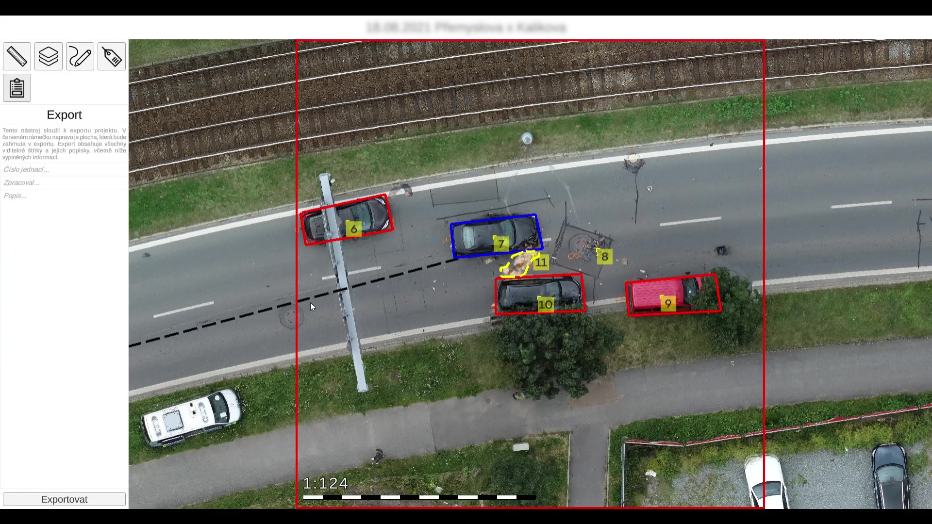
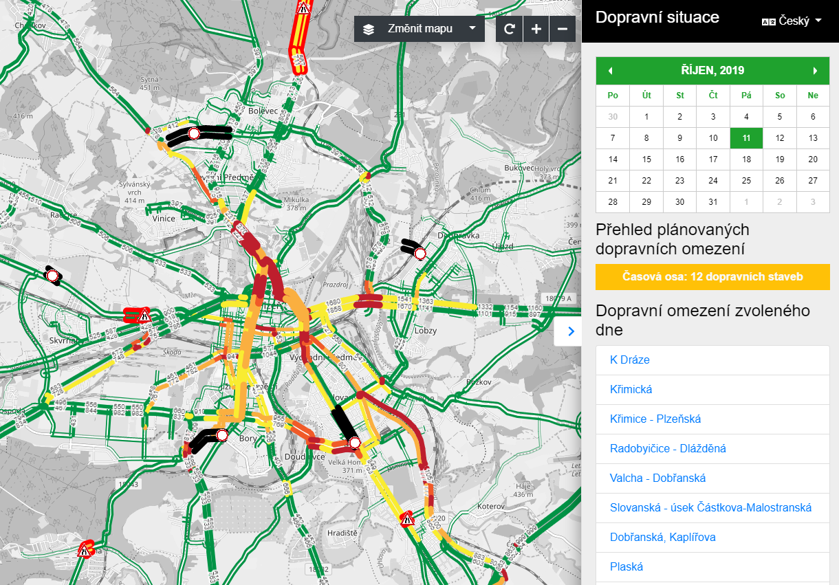
The PoliVisu project also includes the creation of a traffic map of Pilsen based on data from traffic detectors – there are a total of 1,000 of them placed at traffic lights in the city. The application displays the traffic intensity of the most important road sections in the city. It also allows interactive analysis of the number of vehicles measured on 307 sections of city streets equipped with detectors in the form of induction loops. In the application Traffic Modeller of Pilsen, it is possible to view information about the traffic situation in Pilsen from 1 March 2017 until “yesterday”. Each of the displayed sections is interactive and, when clicked on, provides information about its capacity, intensity and traffic level depending on the selected day/hour.
2020
In the last year of the PoliVisu project, the map application Traffic Safety in Pilsen will be developed. The map, in the form of a so-called heat map, visualises data on traffic violations that have been recorded by the Pilsen Municipal Police since 2015, data on traffic accidents that have been recorded by the Police of the Czech Republic in Pilsen since 2016, and traffic violations from radar section measurements that have been kept since 2018. In addition to visualising the data on the map, it is also possible to interactively analyse detailed information on traffic violations and accidents using filters and graphs, thus presenting the researched facts in interconnected graphs and maps.
2021
Although the PoliVisu project will end in 2020, the City of Pilsen continues to work with experts on the further development of the Traffic Modeller. At the end of the year, RoadTwin delivered a new version of the web application for testing, with an improved graphical environment and, most importantly, new functions for traffic modelling. Traffic professionals can now add new road sections to the traffic model, restrict turning directions at junctions and create new traffic generators. The experiments created can be published for public use, as in the case of the agreed planned closures in Pilsen (web application Traffic Intensity in Pilsen). The importance of the project is evidenced by the fact that Traffic Modeller won the Smart Cities 2021 award in the category: “Project for a city with 50-200 thousand inhabitants”, where the judges took into account the solution’s compliance with the principles and pillars of the Smart City, including the criteria of feasibility, sustainability, proven savings, open data, and public participation.
Interesting facts about the project:
*The PoliVisu project is fully funded by the European Science and Research Programme HORIZON 2020, which has a success rate of less than 10% for grant applicants.
*Plzeň is one of three pilot cities involved (along with Ghent, Belgium, and Issy-les-Moulineaux, France), with experts focusing on the transport sector in the west of the country, with a comprehensive focus on everything from car and public transport to pedestrian, cycling and parking systems. The results are part of the Smart City Plzeň concept, which aims to provide solutions for a better life for the inhabitants of the West Bohemian metropolis.
*The traffic visualisation project in Pilsen won an award from the magazine Egovernment in the competition The Best, which aims to present the most interesting projects of electronic public administration in the Czech Republic. The visualisation of traffic intensity in Plzen won first place in the category “City Projects”.
This project will be followed by our next HORIZON 2020 project DUET. In Pilsen, it will focus on the digital twin of the city, its 3D model. Read more about DUET here.
Other projects
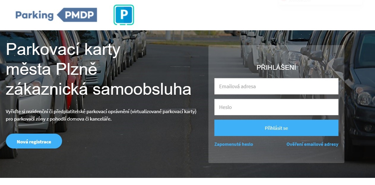
Self-service for Parking Cards
IoT Network

Crash Inspector – App for Traffic Police